Tour to Sillustani Pre-Inca Ruins Outside Puno

While my first night in Puno was plagued by cold and noise, the second one was just cold. But it got really cold. It was reasonably quiet in Hotel Inka Tours, which I desperately needed, but as the wind picked up at night, it got so cold, I could not stop shivering.

I concluded that I simply am not equipped for stay in such a cold place, and made the decision to leave after the second night. Puno was colder than I expected and I simply did not have warm enough clothes to handle the relentlessly cold nights.

I checked out of Hotel Inka Tours at 11am and headed for the bus terminal where I purchased a ticket to Cuzco on an overnight bus. Whereas several providers offered these trips, I specifically asked each one if they would hold my luggage until the bus’ departure at night, so I can go out and do some more exploring during the daytime.

Company Mer was happy to store my luggage until the departure so I bought the ticket with them, and proceeded to make arrangements to get me to the archeological complex of pre-Inka ruins at Sillustani.

Photo: Lama Used as a Lure in Front of House on Way to Silluani to Attract Tourist and Charge Them for Photos

Located on the shores of Lake Umayo in the Umayo Atuncolla district of the province of Puno, the near 40 kilometers long journey to the archeological site involved a bus to the access road from where I took a taxi to cover the last few kilometers.

Having passed by a number of traditional houses with llamas in front of them to attract tourists and charge them for taking pictures of the animals, I found myself at the entrance to Sillustani, which was likewise turned into a tourist trap with numerous sellers of overpriced handicrafts and high-cost bottled water. The use of bathrooms was also one of the most expensive in all of Peru. The entrance fee to the complex was 10 Soles.

Photo: Selfie at Lizard Chullpa

Sillustani was used as a necropolis and is littered with “chullpas” – funerary towers built on the hill overlooking the Umayo lagoon. The location with breathtaking views of the lagoon would make for a captivating trip even if archeological sites are not your thing.

Chullpas of Sillustani

The chullpas are tower like structures built as tombs by the Qulla people, a subgroup of the Aymara indigenous nation, before they were conquered by the Incas, and later by the Spanish.

Photo: Set of Older Chullpas at a Further End of Sillustani

The majority of chullpas at Sillustani are circular and made of stones. In some, the archeologists found mummified bodies particularly well preserved thanks to the cold and dry climate of the Altiplano. The tombs also held ceremonial objects in gold, although the majority is believe to have been lost to grave robbers.

Photo: View of Lizard Chullpa from Location of More Remote Chullpa

All Chullpas have a single, small door facing east. This direction has been symbolically chosen to represent the rebirth of the soul through the sunrise. The oldest Chullpas are said to have been built by the Pukara civilization at around 800 BC.

Photo: Ramp of Rocks Is Presumed to Have Been Used to Get Large Stones on Top of Chullpas

They are spread out across the hill, so even though I kept a decent pace without pausing for too long at any one structure, it took me an hour to get to all the main ones.
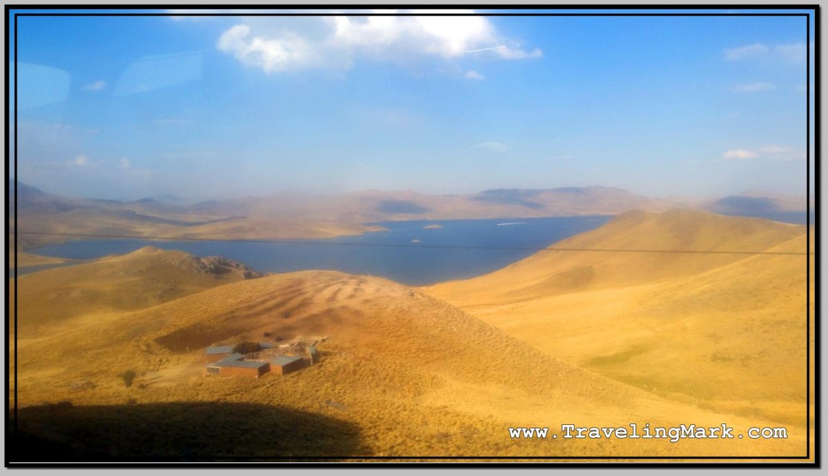
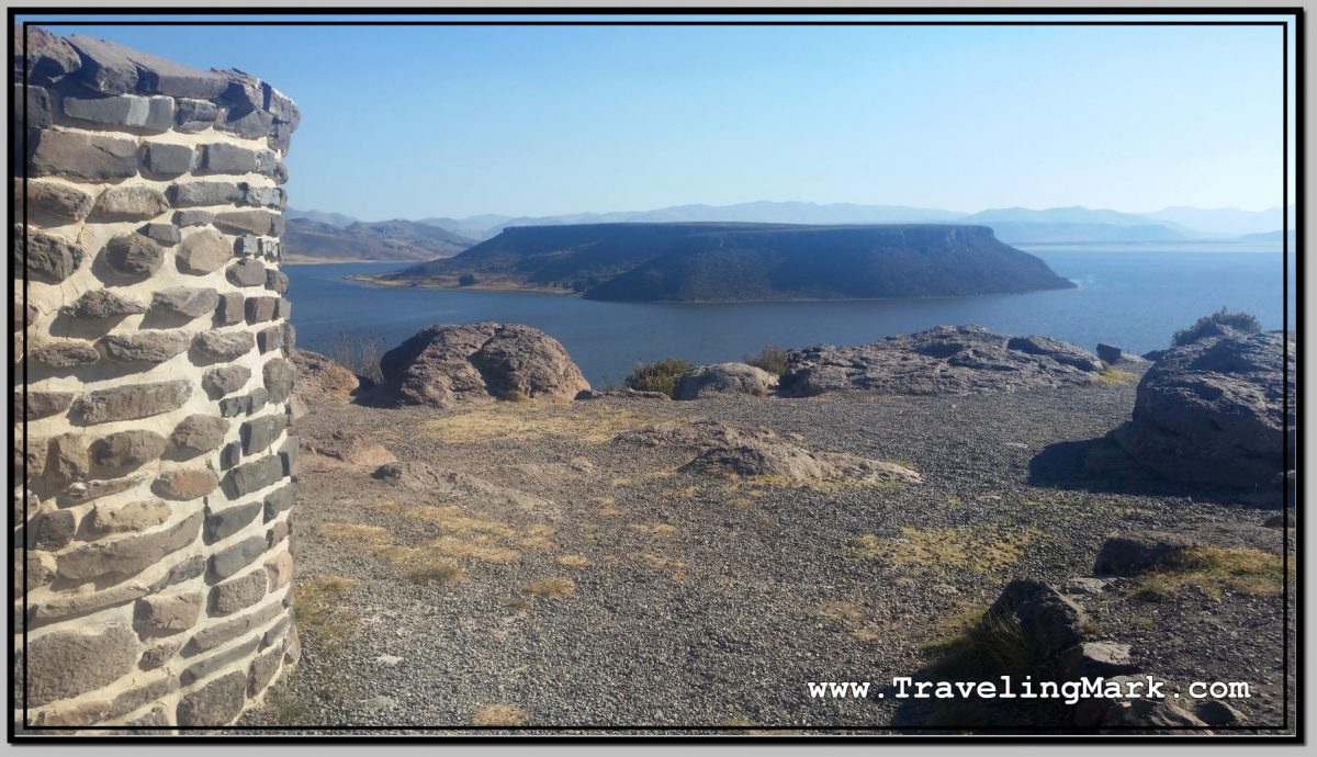
Lake Umayo

You can see the marshy side of Lake Umayo as soon as you enter Sillustani. But its true beauty does not reveal itself to you until you’ve climbed on top of the hill housing the Chullpas. With its flat-top island in the middle and steep cliffs on the fringe, the lake truly rewards the visitor braving the high elevation climb to Sillustani.

Photo: Flat Top Island on Lake Umayo

The 125 hectares large Umayo Island is called Intimoqo by the locals. There are diverse legends surrounding Laguna de Umayo, such as the one that says that its water is saltier because it is the tears of the princess Ururi, who poured them when losing her beloved. In the face of so much pain the Sun hid and there were years of drought and hunger, until their parents guilty of the drama, implored the return of the Sun, but their tears also arrived at the lagoon, making it saltier. After the return of the Sun, only the time and the less suffering of the people made it less salty, so that the fish returned and procreated.

Photo: Partially Collapsed Chullpa with Laguna de Umayo in the Background

What to Expect

The highest point of the area, according to the information I got from the locals, stands at 4,000 meters above sea level, which is a significant elevation so one should take precautions against possible altitude sickness. Having been built on a hill, the walking around Sillustani involves a lot of uphill trekking that is sure to get your heart pumping and lungs gasping for more air.

Photo: Lizard Chullpa Is The Most Iconic

When I was there, the sun was blasting something intense, so making sure you put on sunscreen before heading to Sillustani. At that elevation you have 4 kilometers less of dense air blocking the sun rays compared to the sea level, but even though the temperature would not suggest it, the intensity of the rays is savage despite seeming that way.

Photo: Flowers Like This Surrounded with Thorny Spokes Can Be Found on Sillustani Hill

A light jacket would also come in handy as once you reach the top of the hill, the wind really picks up. I did in in just a long sleeve shirt and was fine, but the biting wind would have been too much for a short sleeve.

Photo: Intiwatana - Ceremonial Circular Structure Build by the Incas
Photo: Intiwatana – Ceremonial Circular Structure Build by the Incas

Overall I found Sillustani overly touristy. The ancient structures were interesting, but for me the highlight were the views of the lagoon surrounding the hill on which the chullpas were built. Make sure you bring your own bottle of water so you’re not left having to buy the overpriced small bottles sold in the local shops lining the sidewalks of the village.

Photo: Chullpa with Umayo Island Inside the Lagoon

Trip to Uros Floating Islands Off Puno on Lake Titicaca

Located at the altitude of near four thousand meters above the sea level, in the cold waters of the highest commercially navigable lake in the world, are a series of artificial islands created by the Uros.

The Uros are an ethnic group originating from Lake Uro-Uro in Bolivia, who, to escape the invasion by the Incas, Tiahuanacos and Collas, took refuge in Lake Titicaca.

Photo: Selfie from Boat Ride to Uros Islands

Titicaca – which means “stone puma” – is according to legend the place from which emerged Viracocha, the Sun God, who in turn sent Manco Cápac to found the prosperous Inca culture in Cuzco.

The floating islands of Uros are up to 3 meters thick and are built with a type of reed called totora that grows in the water. They and are in constant need for maintenance, since totora naturally decomposes with time. Every 20 days a new layer of totora is added on the surface of each island – a job performed exclusively by men.

Photo: Boat Ride to Uros Islands Is Through Maze of Vegetation Growing Over Lake Titicaca

According to the backinfo I for, the Uros consist of 82 artificial islands, each inhabited up to seven families family, and each having its own president. In addition, there are community islands housing a church, a school, a health center, or restaurants. Estimated 1,800 people live on the floating islands, usually related to each other.

Something about the fact that the Uros islands are floating attracted me to them, so before my first day in Puno was over, I decide to take the boat trip there. I went on my own, and not with a tour, so I paid 10 Soles (about $3 US) for the boat ride there and back, plus 5 Soles (about $1.50) for the access to Las Islas del Uros. The latter was a bit off putting, as it’s overall ridiculous to pay for a visit to what is basically a town, but in spite of that, I went for it and paid the cost.

Photo: Motorboating It Through Lake Titicaca to Floating Islands of Uros

The ride in an old boat took a bit over 30 minutes one way. I asked the boatman how exactly it worked with the return journey back to Puno, and he explained to me that the same group of people currently on his boat will be exactly the group of people going on the same boat back. I asked when exactly the journey back takes place, as in to determine how much time I had for exploring Las Islas del Uros, to which he replied that when we arrive, the people on the island would explain everything to me.

Photo: Boat with Which We Arrived on Uros Island Is Docked on Side of Floating Mass

This started to sound a bit fishy to me, and at the time I didn’t know what exactly to make of it. But things became clearer as soon as we arrived.

Basically, the boatman took us to one of the isolated tiny floating islands where we were given short presentation by the locals on the life on the floating island, which was followed by a very aggressive sales pitches to make us, the visitors, buy the trinkets sold on the floating outcrop.

Photo: Trinkets Floating Island Inhabitants Tried to Coerce Visitors Into Buying

My philosophy on buying trinkets has not changed in 10 years of traveling – I travel light and I move from one place to another. That means I have neither the room nor the will to add weight to my baggage. There ain’t nothing any salesperson could say to make me spend money so I can make my backpack heavier than it already is. I only buy what I absolutely need for survival, and that usually happens only when I wear out what I already have and need to replace it.

Photo: No Escape from Small Floating Island Once You Are Brought There

With only about 20 meters in diameter, the floating island on which we were left provided no opportunity to escape the aggressive sellers. Nevertheless, I never bought anything because it would simply make no sense to me.

Photo: AWALT - This Young Peruvian Girl Came to the Same Island as Me with Boyfriend, But Cucked Him Into Taking Picture og Her with Me After Hitting on Me in Front of Him
Photo: AWALT – This Young Peruvian Girl Came to the Same Island as Me with Boyfriend, But Cucked Him Into Taking Picture og Her with Me After Hitting on Me in Front of Him

Having exhausted all the options on the sales of trinkets, the villagers then proceeded to pressure the visitors into boarding their cool looking straw boat they called Mercedes Benz. Without explaining what this was about, they kept telling us to get on board. I was however insistent on explanation whether the presumed ride on said boat is included in the cost of the visit to the island, or whether I’ll be expecting to pay extra for it.

Photo: Type of Boat Referred to As Mercedes Benz Is Used by Locals on Uros Islands to Trick Visitors Into Paying 10 Extra Soles for a Ride

Only after I resolutely declined set foot on the boat unless the intention of the locals is made clear I was clarified that if I get on the boat, I will be charged 10 Soles, but I will be taken for a ride to another island.

A brief chat with other visitors lead to the conclusion that we’re not taking the Mercedes Benz boat, and instead requested the boatman who brought us on this tiny floating outcrop to take us to a bigger island where we were told we’d encounter restaurants and other amenities.

Photo: View of Fishing Boats Trawling Waters Around Uros Fishing Islands

There wasn’t a whole lot to do on the other island either, so we just snapped a few pictures and then asked the boatman to take us back to Puno.

Photo: Scene from Larger Uros Island

Overall I would rate the trip to Uros as a waste. It wasn’t anything akin to taking a boat to an island where you can wander around to explore the place at your own pace. It was about being taken to a very small space where you get exposed to pressure sales tactics without the option to make a physical exit.

Photo: Selfie from Lookout Tower on Uros Island

Considering that the access to the islands costs money to begin with, had I been clearly explained what I’d get if I bought the trip, I would not have bought it. I did not find it worth it at all.

Photo: Our Boat Before Return Ride Back to Puno from Uros Island

Sampling Trout at Port in Puno

The Port of Puno, located on the Lake Titicaca, is a safe and clean area full of shops selling handicrafts, and restaurants serving fish from the lake.

Photo: Ice Age Characters at Port in Puno, Peru

I popped into one to try local trout. I enjoyed fresh and pollution free trout in Papallacta, Ecuador, where it cost $6 US, so I wanted to compare how Peruvian trout compared to the Ecuadorian in both quality and price.

What I liked the most about the restaurants at Puno Port, was that aside from common trucha frita (fried trout), they also offered trucha al vapor (steamed trout). With the nutrients preserved better in steaming as opposed to deep frying, the trout “al vapor” is much healthier and tastier. Certainly a point for Peru.

Photo: Steamed Trout Dish at Port in Puno on Lake Titicaca

I also liked that at Puno Port, I could choose from a vast array of accompaniments, including french fries, baked potatoes, steamed root vegetables, veggie salad, cooked corn, etc. In Ecuador’s Papallacta, trout came with accompaniments too, but they were always set to fries and a bit of salad, with no option to chose what I’d like. However, in Ecuador, unlike in Peru, the trout also came with a bit of a soup and a beverage. This part was a draw.

The Puno trout was beyond compare larger than what you get in Papallacta, and the overall portion of food on the plate was larger too. I’m a big guy and this was my first meal of the day after walking around the city for a few hours, but I could not actually eat all of what I had in front of me (I left steamed potatoes on the plate). This was definitely a point for Peru, as portions in Ecuador were much smaller.

Waters of Late Titicaca are however murky and full of waste from virtually every house in Puno and all other communities on its shores. Many parts around the lake stink like sewage, so trout from Titicaca is certainly filthier than that of Papallacta, where water is crystal clear with nothing around to severely pollute it. A strong point for Ecuador.

Photo: Puno Port Lighthouse

Lastly, the price for the plate of trout in Puno was 16 Soles, which was about $4.84 US at the time of my visit, making the dish in Peru a slightly better deal than in Ecuador. Needless to say, whereas that option existed, when I returned to have trout in the same restaurant again the following day, that time around I only ordered half the fish, which came at half the cost of 8 Soles (about $2,42 US). At that cost, I got about the portion of trout in Ecuador, making Puno a hell of a better deal overall.

While I enjoyed trout in both Papallacta and Puno, and would not hesitate recommending both for anyone visiting either place, I think despite all, I give this one to Peru, as the value for money is simply greater there. And that’s despite the fact that Peru is overall more expensive than Ecuador. It comes to show that good deal can be had even in pricey locations.

The purity of the fish in Ecuador, however can’t be beat. Unfortunately, the purity won’t mean a whole lot if the fish is deep fried in high transfat vegetable oil in the end.

Yummm, trouty!

Battling High Altitude in Puno

Having checked in late at night, once I woke up from the cold night at El Lago Hostel, I went out into the sun filled streets of Puno to unfreeze my bones from the shivers dominated night. The first goal was to find a different hostel to move to, as El Lago simply did not provide reasonable value for the price, and the incessant, night-long screaming made any chance of a restful stay an impossibility.

Photo: Sheep Herder Takes Up Morning Road in Puno, Peru

I moved to Hotel Inka Tours. Not only was the price for the hotel 35 Soles, ie less than at El Lago Hostel, the room was much nicer, the bed more comfortable, the bathroom cleaner, the internet worked and the staff did not make the common area of the hotel a party place for the night.

With the new room for the upcoming night secured, I moved my things over and headed out to the streets of Puno to battle the city’s high altitude on foot.

Photo: Plaza de Armas in Puno with Cathedral in the Background

Plaza de Armas (every city in Peru appears to have a downtown square called Plaza de Armas), was over 2km from the bus terminal near where I was staying, so it took a bit of a nice walk through the city to get there and snap a few pictures of the cathedral and the nearby buildings.

Photo: Basílica Catedral de Puno

On the upper side of Plaza de Armas proudly stands the Cathedral of Puno, also known as the Basilica of San Carlos Borromeo. The baroque cathedral is the main church in the city of Puno. It is under the ownership of the Catholic Church, and was declared a Cultural Historical Heritage of the Nation of Peru in 1972.

Photo: Iglesia de San Carlos Borromeo in Puno

The cathedral is made entirely of stone. The idea for a cathedral of stone reportedly arose from a miner from the area called Miguel de San Román. Indigenous master Simon de Asto was put in charge of building the cathedral – a construction that ended on May 25, 1747.

Photo: Catedral de Puno, Otherwise Known as Basílica de San Carlos Borromeo

From Plaza de Armas, I headed up on the nearby hill on top of which I saw a statue. The unobstructed views from the hill promised opportunities for pictures of Lake Titicaca and the city of Puno itself.

Even though reasonably fit for long walks, ascending the 60 meters high rocky outcrop known as Cerrito Huajsapata in the altitude close to 4 km (3,839 meters above the sea level) was no chore. The shortness of breath was a frequent reminder that I have just arrived in this elevation and my body is not used to it yet, so I need to keep that in mind and take things easy.

Photo: View of Lake Titicaca from Cerrito de Huajsapata

Moreover, kind of like express kidnappings are a well documented threat in Arequipa, Puno is known for its hills being locations of frequent armed robberies of foreigners, so heading up to any of the lookouts is a potential risk for every tourist.

I decided I would not be risking it to the higher hills further out, and will be happy with the one nearest downtown so I don’t end up robbed or worse.

Photo: Police Stationed on Cerrito de Huajsapata

Luckily, the uphill climb in the high elevation city was the only challenge I encountered. As a matter of fact, once up, I saw three policemen nearby, giving the impression of the city having been aware of the bad rep its lookout hills are getting and began stationing police in some of the more popular ones.

Photo: Met These Peruan Girls on Cerrito de Huajsapata

The information sign at Huajsapata Hill stated that Huajsapata is the Quechua word meaning “the highest part of the crag“. The statue on top of the hill is of Inca Monco Copac, the founder of the Inca Empire, who according to legend, was commanded by the Sun God to emerge from the waters of Lake Titicaca.

Photo: Statue of Manco Capac on Cerrito de Huajsapata

The ancient inhabitants of the high plain known as the Altiplano believed that the underground caves beneath Cerrito Huajsapata led to the Koricancha Temple in the city of Cuzco.

Photo: City of Puno and Lake Titicaca Seen from Huajsapata Hill

Overall, I enjoyed exploring Puno on foot, and although I didn’t suffer any of the more severe symptoms of altitude sickness, the high altitude of the place made breathing a challenge at every step and even the lightest physical activity resulted in quick shortness of breath.

Bus Trip from Arequipa to Puno at Lake Titicaca

I stayed in Arequipa for a week. I liked the climate, the city and the surrounding scenery with the dominant Misti Volcano. I didn’t like that frequent and well documented express kidnappings make taking a taxi a super risky business, so I got by without, but overall I truly enjoyed my stay. But after a week of being an Arequipeno, it was time to move on. I decided to head down south to Puno – a city on the shores of Lake Titicaca, located at the elevation of 3,830 meters above sea level.

Being quite familiar with the downtown core of Arequipa, I checked out of Hotel Diplomats at around 10:30am and took a 30 minute walk to the bus terminal. Several operators sold tickets to Puno, so I chose the one whose bus was leaving the soonest. On the map, Puno didn’t seem all that far, so I expected the bus ride to take maybe a couple of hours. I should have seriously looked more into it, instead of assuming the distance as the crow flies would somehow be indicative of the time it would take to get there.

Photo: Alas del Sur Bus Company Services Between Arequipa and Puno

I rode with the company called Alas del Sur. Having mistakenly expected a few hours long bus ride, it was just a local type of nothing-fancy bus. The departure was at 11:30am.

The ridiculous thing about the Arequipa bus terminal was that as always, the hygienic services were charged for – a cost of 50 Centabos, and you were issued a ticket permitting you the use of the bathroom. I got to say that was a first for me.

Photo: Arequipa Bus Terminal Ticket for Use of Toilets

Next ridiculous thing was that there was a 2 Soles terminal tax imposed on everyone looking to depart with a bus from the station. It was kind of like an airport fee you get charged for as part of taking a flight somewhere. After Arequipa, I’ve encountered the bus terminal fee a few time at other terminals in Peru. Peru is ridiculous like that.

Photo: Arequipa Bus Terminal Service Fee

An even more ridiculous thing was that everyone boarding a bus was taken a mugshot of. Even though I’m a citizen of a European Union country, the GDPR was useless to me in Peru. Needless to say, after Arequipa I realized that the mugshot taking in order to be allowed to use a bus you have paid for is a common practice in over-the-top Peru.

The bus left as scheduled at 11:30am, and I truly enjoyed the scenery as we went along. The vegetation-free, arid hills, with towering volcanoes often bearing snow covered caps, were spectacular on every turn.

Photo: Road Sign Warns of Wild Roaming Vicunas

A couple hours after leaving Arequipa we passed through the national park Reserva Nacional Salinas y Aguada Blanca with multiple hoards of wild vacunas roaming about. There were plenty of them on the vast planes of the area, but they were always at a distance from the road, and taking a reasonable picture of them from a moving bus was a challenge.

Photo: Wild Roaming Vicunas in Reserva Nacional Salinas y Aguada Blanca

Somewhere around there I also spotted my first cloud I’ve seen since leaving Ica for Nazca. This part of Peru receives very little precipitation so despite cold nights, days are sun filled with clear blue skies and nothing obstructing the sun for months on end.

Photo: First Cloud in Peru I've Seen Since Leaving Ica
Photo: First Cloud in Peru I’ve Seen Since Leaving Ica

As the sun got lower, we passed by Laguna Lagunillas which I thought was the beginning of Lake Titicaca, but it was still far from it. The hours were passing by and soon enough it became very clear to me that we’re not getting to Puno during daylight. As a matter of fact, by the time we arrived in Puno, it was already past 9pm, making me truly regret not looking into how long the trip to Puno would really take. Had I known I’d waste all daylight if I take a bus during the day, I would have waited in Arequipa to take an overnighter instead, and arrive in Puno in the morning.

Photo: Laguna Lagunillas

Having truly messed up on that, I had no option but look for accommodation in the city I did not know late at night again. What made matters worse was that because of the high altitude and the proximity to the highest commercially navigable lake in the world, nights in Puno are bone-chilling cold.

Luckily, a number of hostels near the bus terminal provided enough opportunity to secure a room rather quickly. The cost for what you get was however off the charts. The problem was then further compounded by the fact that once I paid for a room at El Lago, I realized the internet in the hostel was spotty, frequently cutting off so every simple task took a very long time to complete.

Photo: Hostal El Lago in Puno, Peru

The rooms in the hostel were not heated, so the incredible cold of the night outside made any possibility of having a decent rest overnight a challenge at best. Likewise, the shower water was only a little warmer than fully cold, having only been warmed up by the daytime sun. Needless to say, taking showers in cold water when you’re shivering to begin with was an adventure in its own right.

The hostel also did not provide a roll of a toilet paper, but instead just a few sheets torn off from a roll. At 40 Soles per night, it was definitely one of the worst deals for the money I’ve had in Peru. But then again, I found Peru to be expensive in general. Especially when value for money is concerned.

The worst part of staying at El Lago, however, was the constant noise from incessant screaming and loud talking by the guy at the reception with his mates. Earplugs were of little relief against the party-night type banter in the place.

Nevertheless, the brutally cold night didn’t kill me and come morning, I was ready to truly hit it in Puno.

Cold Summer Nights in Canadian Wilderness

One of the earliest things I learned when I left to live as a recluse in the Canadian wilderness was that nights out there are extremely cold even in Summer. I did my hermit experience over the warmest months of the year – June, July and August, but while it was nice and warm during the day, night time temperatures dropped below zero. And since I didn’t anticipate freezing temperatures, I neither had clothes, nor other equipment (sleeping bag, tent or stove) to keep me warm at night.

Photo: Just Before Sun Rise, When Temperature Was at Its Lowest, the Lake Started to Turn Into Vapor

The lake I chose for my stay away from civilization was very remote, but – to a point – accessible by car. The nearest paved road to the lake was more than 100km away but invasive logging industry left a passage through the forest which I was able to use to get myself closer. Needless to say, this forestry equipment road was full of obstacles and rough terrain that’s normally only negotiable by heavy machinery with continuous tracks, but being a skilled driver and having been blessed with dry weather, I was able to safely traverse this incredibly challenging stretch of the road all the way to the lake.

The entire journey took me about 5 hours to complete, but I was only about 300 km north of Edmonton as the raven fly. I don’t know whether it was these extra 300 km north or the fact that there is no civilization anywhere near the lake, but as someone who spent countless Summer nights outside while living in Edmonton, I can tell you for sure that while it does get cold at night even in Summer, it doesn’t get below freezing. Not in Summer. But as I learned after my first night out in the wilderness (and each night thereafter), despite daytime temperatures reaching pleasant 29 °C, they were followed by night time drops to -3 °C.

5 hour long drive north of Edmonton and you’ll experience brief Winter every night even during Summer months. I personally think this had more to do with complete remoteness of the wilderness than its placement along the longitude. I have not done any scientific research on it, but high concentration of warm bloodied mammals who radiate body heat into the environment surely contributes to keeping the temperature in urban centers warmer than in the wilderness. And it’s not only body heat – you have heat generating car engines, thousands of computers, stoves used for cooking, machines used in factories, people bathing in hot water – so many things to keep the environment warmer… And on top of it all, you have pollution that keeps the heat trapped.

During my first month in the wilderness, it rained almost every afternoon. July was a little better and come August, there was hardly any rain. Sky was cloudless most of the days with sun baking down on me from wee morning hours until late night. Yet even in August, when daytime temperatures were in their 30’s, as soon as the sun was gone, the gauge started dropping rapidly and got to freezing just before the dawn.

Luckily, I had everything I needed to keep the fire going and there was plenty of dry firewood around, plus night only lasts a few hours a day this time of year so even though ill equipped, I kept myself warm-ish by utilizing natural resources. Regardless, it was a lesson I learned the hard way – remote Canadian wilderness can be very cold even in Summer months. Especially at night.

In order to survive, I had to swap night with the day. I got most of my sleep during the day when it was warm and I didn’t have to spend time feeding the fire and when the sun went down, I kept myself entertained by staring at the stars. It’s mind boggling how many of them there are and how clearly they can be seen when you’re away from city lights and pollution.

First night was hands down the worst but I got right down to building a primitive shelter that would tightly wrap around the bed of dry leaves the following day. I kept improving on my natural tent every day, but night time temperature drops were just so severe, I quickly realized that the only way to stay warm at night would be by building a shelter big enough to have a fire inside. If such shelter was well isolated, the fire would keep the interior warm even during freezing nights. One would still need to feed the fire, but pay back in feeling warm over night would be well worth it.

Sras Srang

Sras Srang is a man made, rectangular shaped water reservoir located just across the road from the Banteay Kdei temple. Many water reservoirs were integrated into the designs of ancient cities of Angkor but nowadays, most are dried out. Sras Srang is one of the few still holding water which lead to speculations that it may have been a natural lake prior to its transformation.

Photo: Sras Srang Water Reservoir at Angkor, Cambodia

Built during the reign of Rajendravarman II, Sras Srang was designed by the Buddhist scholar Kavindrarimathana whose name is the only name of an Angkorian era architect that survived and is known to us today. In Khmer language, Sras Srang translates into “royal bathing pool” which, given the size of Sras Srang was quite the pool. Being 350 meters wide and 700 meters long, it takes 30 minutes of brisk walk to just go around it.

It is quite possible that the original access route to Sras Srang was via Prasat Bat Chum, which would explain its inscription which requests the elephant owner to prevent their animals from trampling the dikes and polluting the water. Later date construction of Banteay Kdei has moved the access point to the lake’s west bank.

Photo: Sras Srang Before Dawn

There is a small, artificial island right in the middle of Sras Srang. It is believed that it once housed a small temple, but that has since been washed away. The western side of Sras Srang, the one immediately accessible from the road one which you will ride to access the lake contains a decorated, laterite landing stage for boats. This was added during the reign of king Jayavarman VII two centuries later. King Jayavarman VII is also believed to have ordered the sandstone facing of the dykes which also resulted in shortening of the original (larger) lake into its current size.

Photo: Sras Srang Boat Platform with Stone Lions and Naga Balustrades

Landing stage on the western dyke is decorated with naga balustrades and guardian lions flanking both sides of the stairs. These decoration are rather damaged with parts of them missing making for a lack of impressiveness upon an initial visit to the reservoir. As a result, most visitors don’t spend more than a few minutes at the lake.

Photo: Boat Platform Steps of Sras Srang Flanked by Stone Lions

It is quite likely that Sras Srang was originally flooded all the way to the edge but nowadays the water barely reaches half way. Still, considering that many other Angkorian era barays (water reservoirs) are dry now, Sras Srang is doing pretty well.

I spent much of my time in Cambodia involved with the village on the south bank of the lake and found the abuse of it alarming. Villagers have been using Sras Srang the same way other bodies of water in Cambodia are used – as a general dump site into which they piss and shit. It is also where people bathe using non bio-degradable soaps and wash their clothes in using non bio-degradable washing powders. Thanks to its great size, Sras Srang still looks like a large lake, rather than a large septic tank, but how long before the scales are tipped?

Photo: Villagers Bathing in Sras Srang at Dusk

Environment doesn’t seem to be on the radar of anyone in Cambodia. It’s usually only through funding provided by some foreign organizations if any part of the natural treasures gets non destructive treatment. For months I had tried to explain the villagers that it should be their foremost interest to protect Sras Srang as it’s their lake, the lake by which they live but it all seemed to have fallen on deaf ears.

Photo: Sras Srang View from the Village - Not Many Tourists Get to See it From This Perspective

I was told that their predecessors used to bath and wash their clothes in the lake for centuries yet the lake is still there, so why should they start getting concerned about it and change their behaviour now. What they don’t realize, though is that their predecessors probably used some organic compounds (coconut extract or who knows what?) as washing fluid, not any of those cheap, chemically produced non bio-degradable powders the villagers use today. No matter how hard I tried, it has not stopped anyone from abusing their own lake or taking any kind of measure to prevent an unavoidable bad ending to it.

Photo: View of Sras Srang from the West Bank with Sky Reflection on the Surface

Sras Srang is still there today and it’s still flooded. Thanks to its size, the lake offers quite a buffer zone so it may be able to take a lot more abuse before it’s irreversible destruction is complete. It’s just sad that none of the villagers showed any form of interest in protecting their own front yard. Perhaps when the lake quits on them they will realize what they had done but by that time it will already be too late.