Ollantaytambo Off the Beaten Path – Inca Bridge and the Pyramid

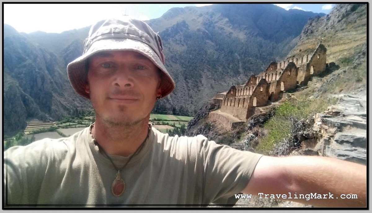
Having arrived from Cusco, gotten a room, explored the ruins on the Pinkuylluna Mountain, and filled my belly with fried trout, I felt like I’ve seized the day pretty well, but whereas I still had an hour until the sunset, I decide to get off the beaten path in Ollantaytambo and explored its least visited areas.

Photo: Pedestrian Uses Suspension Bridge to Walk Toward the Pyramid

I found out while messing around the town’s main square of Plaza de Armas that just outside of the town boundaries on Ollantaytambo’s south-east side, can be encountered the ruins of an ancient Inca bridge, and that near said bridge lay also the ruins of an Inca pyramid. I hit it off to check those out.

Getting to the Inca Bridge

I started the walk from the south-eastern corner of Plaza de Armas and followed the road due east, passing the small market with incredibly overpriced fruits (Peru is expensive to begin with, but it’s even worse as you get closer to Machu Picchu – Ollantaytambo was second only to Aguas Calientes, which is at the foot of Machu Picchu), and onward down the road, until I reached a T intersection. There I turned left and after a few meters immediately right to carry on due east.

On that road I passed Inka Paradise hotel and some kind of a school, after which there was a narrow pedestrian dirt road through a field. That road leads to the bridge. Except at the end of it, there’s a cliff that needs to be descended so if you didn’t take the stroll in your hiking boots, you will only get to enjoy the bird’s eye view of the bridge, and no pyramid.

Photo: Bird's Eye View of Suspension Bridge Built Over Old Inca Bridge
Photo: Bird’s Eye View of Suspension Bridge Built Over Old Inca Bridge

An alternative is to go around town by following the road back to Cusco, but that road is narrow with no sidewalks to safely walk on and the drivers don’t pay much respect to pedestrians.

Inca Bridge

There isn’t a whole lot left of the ancient Inca Bridge. Just the support column erected in the middle of the Vilcanota river still holds the original stones used for its constructions. Nowadays, a newly built suspension bridge connects that banks of the river, still utilizing the remnants of the old Inca structure.

Photo: Rocks in the Middle of the River Are Remains of the Old Inca Bridge

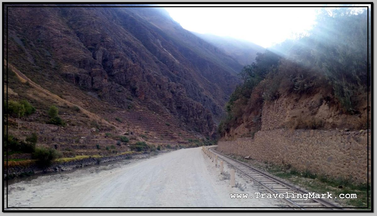
Along the Ollantaytambo side of the river there are railway tracks leading to Aguas Calientes, but no road so tourists don’t have the means to get themselves near Machu Picchu, and are stuck having to use the train for which they are charged more than 100 times the cost of the locals. It is a major and blatantly deliberate rip off which I refused to support.

Photo: PeruRail Train Passed By While I Was on the Inca Bridge in Ollantaytambo

While I was at the bridge, a train with ripped off tourists returning from Machu Picchu back into Cusco passed bay.

Ollantaytambo Inca Pyramid

On the other side of the tracks from the bridge is the pyramid. It is a cascading stone structure build into the slope. I didn’t come across any reasonable kind of backinfo about the pyramid, except that it’s there, near the bridge next to the tracks.

Photo: Ollantaytambo Inca Pyramid Seen from the Opposite Side of the River

Te pyramid had a set of protruding stones built into the outer wall, to serve as steps for ascend. Despite dodgy looking purpose, those steps are solid and absolutely safe to walk on, having withstood the test of time – centuries after being built, they are still there in their original form after affording countless people the way up on the pyramid.

Photo: Rock Steps Built Into the Outer Wall of Ollantaytambo Pyramid

Because the way I came to the area involved a descend down a very steep cliff including a near 2 meter jump, going the same way back was not an option, so I walked around town down the paved road from Cusco.

The vast majority of people who come to Ollantaytambo will only visit the fortress – having shelled out some $43 for the entrance to the archeological sites within the Sacred Valley of the Incas. They come on buses as part of organized tours which only take them to the fortress and nowhere else. So whereas the fortress is overrun with hundreds of tourists every single day, the nearby Pinkuylluna Mountain, which is free to visit receives very few visitors, but when it comes to the Inca Bridge and the Pyramid on the opposite side of the river, your chances of spotting another tourist around them are next to none.

Hike Up Pinkuylluna Mountain to Ruins of Inca Storehouses in Ollantaytambo

While Ruins of Ollantaytambo are the main archeological attraction in the town of Ollantaytambo, I left them out of my itinerary, as I did many other major archeological sites in and around Cusco, because the entrance fee to those is 140 Soles ($42 US). I simply refuse to support the rip off practices of this magnitude, unless it’s something I could not, for the life of me, afford to miss out on.

Photo: Inside Pinkuylluna Warehouse Ruins

Good thing about Ollantaytambo is that on the opposite side of the town from the main archeological site, is steeply towering Pinkuylluna Mountain, on which there are multiple smaller ruins of Inca storehouses and access to those is entirely free. The only challenge is that one must climb on foot the steel slopes of Pinkuylluna Hill in order to access them. But that’s an adventure in its own right that would be worth while even if there were no ruins on Pinkuylluna. Hell yes I was up for it.

And I wasted no time. As soon as I checked in the Inka Wasi Hostal, I put on Shea Butter which I use as purely natural sun screen, and headed out to hit the slopes.

Face of Viracocha

One quickly observable feature of the Pinkuylluna Mountain is the Profile of the Inca (Perfil del Inca). Said to represent the face of Viracocha – the supreme god of the Incas, the father of all other Inca gods and the creator of the earth.

Photo: Face of the Inca Carved Into Rock Next to Storehouse on Pinkuylluna Mountain

I was told by a local that the face on the side of the mountain is not an orographic whim, but it was sculpted in the rock, and it fulfills an astronomical function related to the seasons – the cultivation cycles – illuminating itself in the solstices in a certain way.

Access to Pinkuylluna Mountain

From Plaza de Armas, enter the old town of Ollantaytambo by way of the street the nearest to the hill (rightmost when facing the old town from Plaza de Armas). Follow the narrow, cobblestone street until you come across a gate on the right hand side.

Photo: Pinkuylluna Hill Entrance Gate

The steep rock steps begin right on the other side of the gate. On the left side of the gate there is a sign informing you that you are at the entrance to the Pinkuylluna Mountain.

Climbing the Pinkuylluna Mountain

The trail up the Pinkuylluna Mountain will get your heart pumping right off the bat. Climbing the hill is basically one major cardio exercise, so by taking the hill on, you’ll get the combination of good heart workout, the best views of the town as well as the main ruins, and the ability to get up close and personal with the storehouse ruins without shelling out a dime.

Photo: Pinkuylluna Mountain Storehouses with Uneven Rock Trail

There were moments during my climb when the gusts of wind were super strong, so not only did I have to hold on to my hat, I had to carefully watch my footing on the narrow rocky trail with deep abyss on its side. If you’re a thrill seeker, you’re gonna love walking the cliff edges of the hill.

Storehouses

The Pinkuylluna storehouses, or mountain granaries, are rectangular structures perched on various parts of the Pinkuylluna Mountain.

Photo: Selfie in Front of Storehouse Ruins on Pinkuylluna Hill

Although the placement of these warehouses on top of the hill may seems strange, the fact that at that height the air is cooler and it moves faster, would help in preserving the food and keeping it ventilated. I also tend to doubt the exhausting hike needed in order to reach the storehouses would attract many would be thieves.

Photo: Main Ollantaytambo Ruins Are Better Visible from Pinkuylluna Mountain

Overall, even though challenging, I found the hike up the Pinkuylluna Mountain, and the exploring the storehouses to be a rewarding experience that was totally worth the effort.

Moreover, with the amazing views of the main Inca fortress, I was happy to be on the hill where there were hardly any other people around, and not within the overcrowded main ruins overrun with thousands of tourists.

Photo: Pinkuylluna Ruins with Town of Ollantaytambo in the Background

If you continue all the way to the top, the ever fainter trail will take you around the hill where you will find a small cave. Few people, including locals, even know about the cave.

Photo: Cave in the Back of Pinkuylluna Mountain

If you’re easily spooked, or suffer from vertigo, a climb up the Pinkuylluna Mountain may be hazardous, but in every other case I would certainly recommend it as an alternative to the overpriced and overcrowded main ruins of Ollantaytambo.

Photo: Bird's Eye View of Ollantaytambo Town with Section of Storehouse Ruins on Pinkuylluna Mountain
Photo: Bird’s Eye View of Ollantaytambo Town with Section of Storehouse Ruins on Pinkuylluna Mountain

Here’s a video of bits and pieces I filmed while hiking the Pinkuylluna Mountain. At times the wind gusts were extremely strong:

Tour to Sillustani Pre-Inca Ruins Outside Puno

While my first night in Puno was plagued by cold and noise, the second one was just cold. But it got really cold. It was reasonably quiet in Hotel Inka Tours, which I desperately needed, but as the wind picked up at night, it got so cold, I could not stop shivering.

I concluded that I simply am not equipped for stay in such a cold place, and made the decision to leave after the second night. Puno was colder than I expected and I simply did not have warm enough clothes to handle the relentlessly cold nights.

I checked out of Hotel Inka Tours at 11am and headed for the bus terminal where I purchased a ticket to Cuzco on an overnight bus. Whereas several providers offered these trips, I specifically asked each one if they would hold my luggage until the bus’ departure at night, so I can go out and do some more exploring during the daytime.

Company Mer was happy to store my luggage until the departure so I bought the ticket with them, and proceeded to make arrangements to get me to the archeological complex of pre-Inka ruins at Sillustani.

Photo: Lama Used as a Lure in Front of House on Way to Silluani to Attract Tourist and Charge Them for Photos

Located on the shores of Lake Umayo in the Umayo Atuncolla district of the province of Puno, the near 40 kilometers long journey to the archeological site involved a bus to the access road from where I took a taxi to cover the last few kilometers.

Having passed by a number of traditional houses with llamas in front of them to attract tourists and charge them for taking pictures of the animals, I found myself at the entrance to Sillustani, which was likewise turned into a tourist trap with numerous sellers of overpriced handicrafts and high-cost bottled water. The use of bathrooms was also one of the most expensive in all of Peru. The entrance fee to the complex was 10 Soles.

Photo: Selfie at Lizard Chullpa

Sillustani was used as a necropolis and is littered with “chullpas” – funerary towers built on the hill overlooking the Umayo lagoon. The location with breathtaking views of the lagoon would make for a captivating trip even if archeological sites are not your thing.

Chullpas of Sillustani

The chullpas are tower like structures built as tombs by the Qulla people, a subgroup of the Aymara indigenous nation, before they were conquered by the Incas, and later by the Spanish.

Photo: Set of Older Chullpas at a Further End of Sillustani

The majority of chullpas at Sillustani are circular and made of stones. In some, the archeologists found mummified bodies particularly well preserved thanks to the cold and dry climate of the Altiplano. The tombs also held ceremonial objects in gold, although the majority is believe to have been lost to grave robbers.

Photo: View of Lizard Chullpa from Location of More Remote Chullpa

All Chullpas have a single, small door facing east. This direction has been symbolically chosen to represent the rebirth of the soul through the sunrise. The oldest Chullpas are said to have been built by the Pukara civilization at around 800 BC.

Photo: Ramp of Rocks Is Presumed to Have Been Used to Get Large Stones on Top of Chullpas

They are spread out across the hill, so even though I kept a decent pace without pausing for too long at any one structure, it took me an hour to get to all the main ones.

Lake Umayo

You can see the marshy side of Lake Umayo as soon as you enter Sillustani. But its true beauty does not reveal itself to you until you’ve climbed on top of the hill housing the Chullpas. With its flat-top island in the middle and steep cliffs on the fringe, the lake truly rewards the visitor braving the high elevation climb to Sillustani.

Photo: Flat Top Island on Lake Umayo

The 125 hectares large Umayo Island is called Intimoqo by the locals. There are diverse legends surrounding Laguna de Umayo, such as the one that says that its water is saltier because it is the tears of the princess Ururi, who poured them when losing her beloved. In the face of so much pain the Sun hid and there were years of drought and hunger, until their parents guilty of the drama, implored the return of the Sun, but their tears also arrived at the lagoon, making it saltier. After the return of the Sun, only the time and the less suffering of the people made it less salty, so that the fish returned and procreated.

Photo: Partially Collapsed Chullpa with Laguna de Umayo in the Background

What to Expect

The highest point of the area, according to the information I got from the locals, stands at 4,000 meters above sea level, which is a significant elevation so one should take precautions against possible altitude sickness. Having been built on a hill, the walking around Sillustani involves a lot of uphill trekking that is sure to get your heart pumping and lungs gasping for more air.

Photo: Lizard Chullpa Is The Most Iconic

When I was there, the sun was blasting something intense, so making sure you put on sunscreen before heading to Sillustani. At that elevation you have 4 kilometers less of dense air blocking the sun rays compared to the sea level, but even though the temperature would not suggest it, the intensity of the rays is savage despite seeming that way.

Photo: Flowers Like This Surrounded with Thorny Spokes Can Be Found on Sillustani Hill

A light jacket would also come in handy as once you reach the top of the hill, the wind really picks up. I did in in just a long sleeve shirt and was fine, but the biting wind would have been too much for a short sleeve.

Photo: Intiwatana - Ceremonial Circular Structure Build by the Incas
Photo: Intiwatana – Ceremonial Circular Structure Build by the Incas

Overall I found Sillustani overly touristy. The ancient structures were interesting, but for me the highlight were the views of the lagoon surrounding the hill on which the chullpas were built. Make sure you bring your own bottle of water so you’re not left having to buy the overpriced small bottles sold in the local shops lining the sidewalks of the village.

Photo: Chullpa with Umayo Island Inside the Lagoon